


Kenya Met Warns of Severe Weather Disruptions and Health Risks in New Forecast
All 47 counties face a week of heavy showers, thunderstorms, and mounting public health risks as the country enters an above-average rainfall season compounded by a strengthening El Niño phenomenon.
The Kenya Meteorological Service Authority released a weekly outlook covering November 3 to 10, warning that enhanced precipitation will touch every corner of the nation. Acting Director Edward Muriuki stated that November and December are projected to receive above-average rainfall, offering much-needed relief to agricultural regions and dry pastures following below-to-near-average conditions in October.
However, the impending downpours bring severe infrastructural and health hazards. Muriuki cautioned that excessive rainfall could trigger flash floods, riverine flooding, and landslides in low-lying areas, poorly drained urban centres, coastal regions, and highland zones.
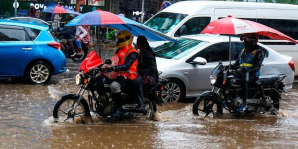
Recent weather already signaled the threat. On October 31, heavy downpours in Nairobi triggered flash floods that disrupted traffic and left vehicles stranded on submerged roads. In October, the highest monthly rainfall total was recorded at an automatic weather station at Ng'iya Primary School in Siaya, reaching 264.4mm, while stations in Marsabit, Garissa, Mandera, Kisii, Kisumu, and Lamu also exceeded their usual monthly amounts.
The latest forecast outlines distinct weather patterns across the country through November 10. Morning showers are expected in parts of Kwale, Mombasa, Kilifi, Tana River, and Lamu, alongside Embu, Garissa, Isiolo, Kajiado, Kiambu, Kirinyaga, Kitui, Machakos, Makueni, Mandera, Marsabit, Meru, Murang'a, Nairobi, Nyandarua, Nyeri, Tharaka-Nithi, and Wajir. Sunny intervals will prevail during the morning in western Kenya, parts of the Rift Valley, and Nyanza.
Afternoon showers and thunderstorms are likely across western Kenya, the Rift Valley, Nyanza, and parts of central Kenya, including Baringo, Bomet, Bungoma, Busia, Elgeyo Marakwet, Homa Bay, Kakamega, Kericho, Kisii, Kisumu, Migori, Nakuru, Nandi, Narok, Nyamira, Samburu, Siaya, Trans Nzoia, Uasin Gishu, Vihiga, and West Pokot. Similar afternoon storms are anticipated in Embu, Isiolo, Kajiado, Kiambu, Kirinyaga, Kitui, Laikipia, Machakos, Makueni, Mandera, Marsabit, Meru, Murang'a, Nairobi, Nyandarua, Nyeri, Tharaka-Nithi, and Wajir, while Turkana will experience sunny afternoon intervals.
Night showers are projected for Embu, Isiolo, Kiambu, Kirinyaga, Kitui, Machakos, Makueni, Meru, Murang'a, Nairobi, Nyandarua, Nyeri, and Tharaka-Nithi, with partly cloudy conditions expected across most other counties.
Temperature extremes will also define the week. High daytime temperatures exceeding 35°C are forecast for parts of Garissa, Wajir, Tana River, Isiolo, Kilifi, Marsabit, Samburu, and Turkana. Nairobi and Kakamega will reach 31°C, while Kisumu, Kisii, and Nakuru will record 30°C. Conversely, minimum night-time temperatures are expected to plunge below 10°C in selected highland pockets of Meru, Tharaka-Nithi, Nyeri, Nakuru, and Kajiado.
Public health authorities face heightened concerns over disease outbreaks. Accumulated water and poor drainage create ideal breeding grounds for mosquitoes, raising malaria transmission risks. Furthermore, contaminated water sources could accelerate the spread of cholera, typhoid, and diarrhoeal infections.
Transport networks are similarly vulnerable. Prolonged rainfall threatens to deteriorate rural access roads, rendering them impassable and disrupting the movement of people, goods, and agricultural produce to markets. Urban centres face severe traffic congestion where drainage systems fail.
On a broader scale, the World Meteorological Organization reported that the El Niño phenomenon is strengthening and projected to peak around December 2026, with a high likelihood of persisting through February 2027. Sea-surface temperatures in the tropical Pacific Ocean are expected to reach approximately 3.8°C above average between November 2026 and January 2027, potentially creating a very strong event.
While the rains will replenish rivers, dams, water pans, and groundwater sources to sustain livelihoods and agriculture, the meteorological authority has advised Kenyans to closely monitor shorter-term weather updates alongside the weekly forecast to navigate the unfolding seasonal hazards safely.





Comments
No comments yet — be the first.